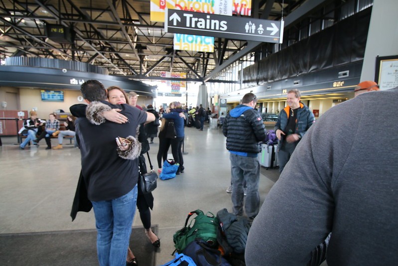
I will be putting out a day-by-day post for the next eight days outlining what we would have been doing if this had been a normal year. Today we start the journey from the Ottawa train station.
This post will grow each day as we go through the days of our Kilimanjaro trek.
Departure date: 25 July – arrival Kilimanjaro: 26 July
Air France
bus Ottawa-Montreal + flight Montreal-Paris-Nairobi-Kilimanjaro
Departs with the whole group at 3:00 pm, we arrive at the airport in Montreal at 5:00pm. Around 10:00 pm, we board the plane for Paris and arrive around 10:30 am on Sunday, July 26. Soon after, we leave for Nairobi, Kenya, then on to Kilimanjaro International Airport
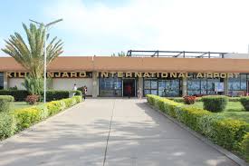
leaving from the Ottawa train station in 2017Kilimanjaro International Airport
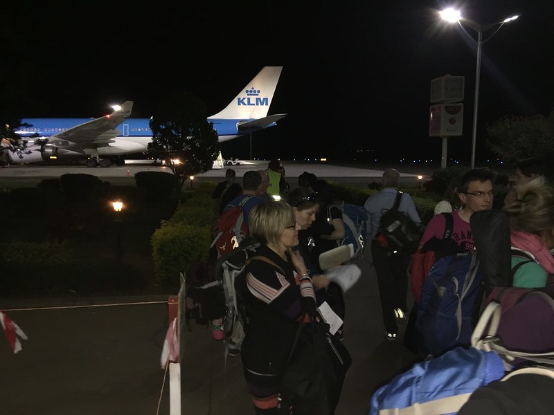
Day 2 is really a transit day. We are in the air for 15 hours, with stops in Paris and Nairobi. We will arrive very late at the airport in Arusha.
Jomo Kenyatta International Airport
Day Two – in transit
CDG PARIS DE GAULLE, FRANCE 10:45 am.
Arrive NBO NAIROBI KENYATTA, KENYA 20:55 pm –
Arrive JRO KILIMANJARO, TANZANIA 23:50pm (7-hour difference) – 15 hours flying time
finally arriving at the airport in Arusha – 15 hours in flight
We advise group members to wear their trekking boots on the flight over – if luggage is lost it is difficult to replace your boots. That is a long time in your boots!
We have added in a rest day so we can start to recover from any jet lag and hopefully spend some time getting to see Arusha. It will be good to arrive.
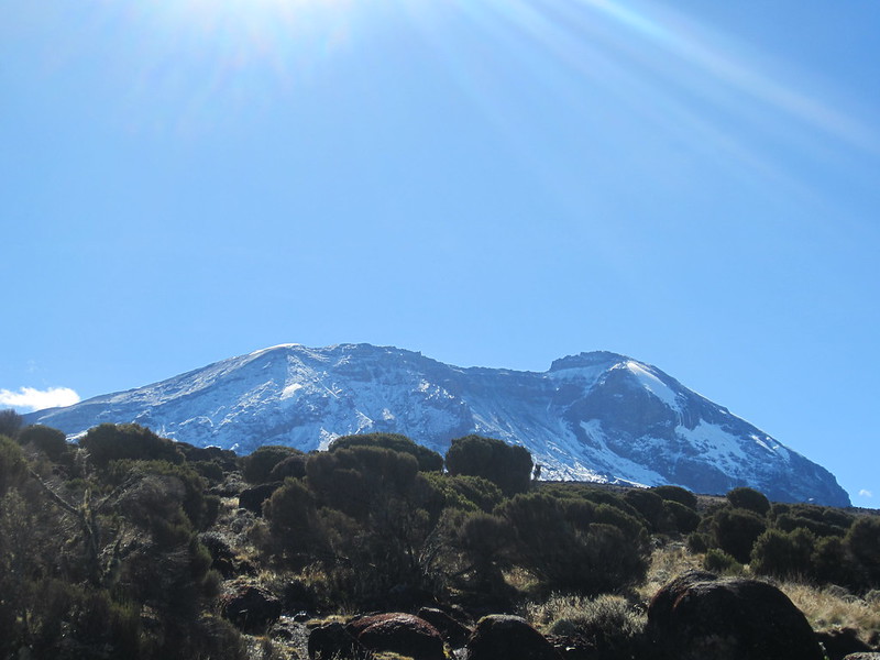
Always with the mountain at our back.
Day Three – July 27th, a rest day in Arusha.
This is a good day to take it easy and get your gear together. You will have to weigh your gear to make sure you are not over what you are allowed to bring with you. Extra luggage will be left at the lodge.
There should be a scale at the hotel so you can weigh your bag. Extra stuff can be left at the hotel. It took me a while to get my weight right!
The rest of the day will be yours to relax, maybe go into Arusha and we will have our team meeting.
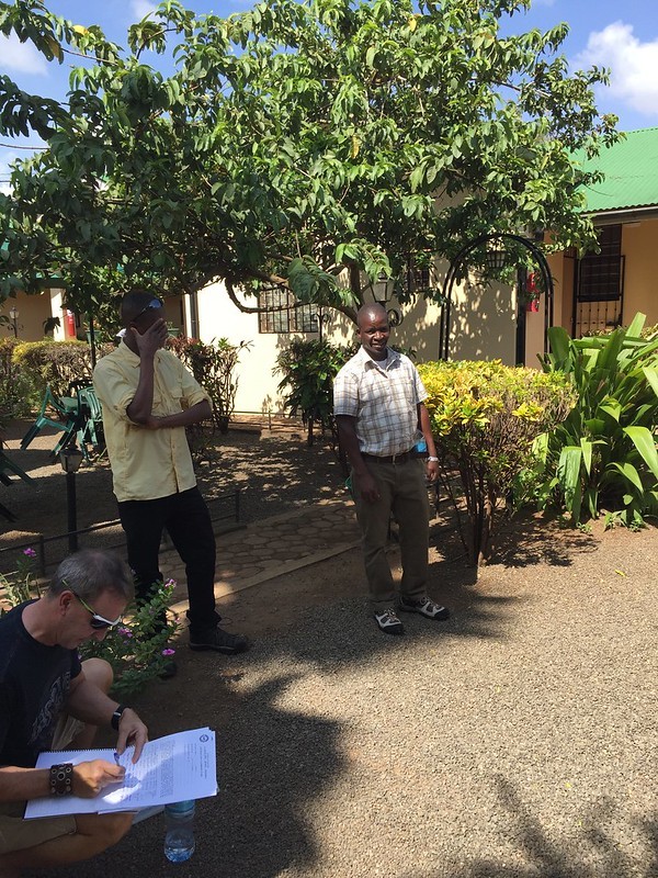
A tour of Arusha
Team Meeting – There will be a trip briefing this afternoon/evening. Please bring with you your passport and insurance details, and your air ticket details. The briefing will cover all aspects of your trip and will include the distribution of any hired equipment you have booked.
Our group briefing with our head guide, Living Maleo
Tomorrow we start for the beginning of the Lemosho Route!
First day on the trail
To Londorossi; begin ascent to Lemosho Forest (2650m).
In the morning we transfer to Londorossi (2250 m), passing between the slopes of Kilimanjaro and the horseshoe-shaped volcanic crater of Mt. Meru
(a distance of about 120 km).
After completing the necessary registration formalities, we drive on for a short distance through farmland and plantations to reach the Lemosho road head. The last 5 km of the road to the park gate is of poor quality, particularly after rain, and the drive there should be considered part of the adventure.
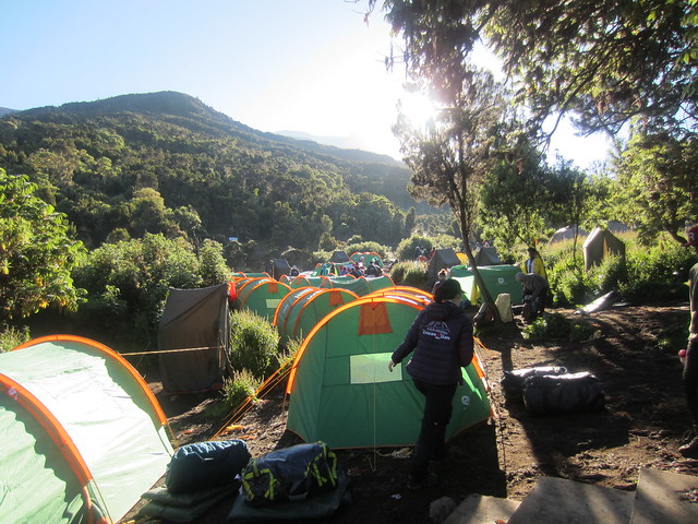
We often have our lunch in the glades before starting to walk. It is an easy day of walking up a small path through beautiful and lush forest, this area has a variety of game including buffalo. We camp at Lemosho Forest camp (2650 m). Approx 3-4 hours walking.
a video of the first day showing the weighing of bags at the trailhead and the beautiful vegetation at the beginning of the trek
our campsite after our first day of trekking in 2017
July 29 – Day Two
Explore Shira Plateau; camp at Shira One (3550m).
The trail starts out in the lush rich montane forest before ascending into the moorland zone of giant heather. The trail climbs steadily with views across
the plains opening out as we reach the rim of the Shira Plateau. There is a tangible sense of wilderness especially if the afternoon mists come in. We camp in the centre of the plateau at Shira One (3550 m). Approx 6-7 hours walking.
Shira One Camp, the summit is in the background
If you take a look at the altitude at Shira One, you will see it is over 3000m. Once you get over that boundary, you really begin to feel the altitude. Every effort becomes a challenge and you really need to take things slowly and be mindful of what you are doing. This is the world you live in for the next week.
These short videos give you a sense of what it is like on each stage of the Lemosho Route – no commentary, just the trail.
July 30 – Day Three
Walk to the summit of Shira Cathedral to camp at Shira Hut (3840m).
A day to help acclimatization and to explore the grassy moorland and the volcanic rock formations of the plateau. We walk to the summit of Shira Cathedral, a huge buttress of rock surrounded by steep spires and pinnacles.
Shira Cathedral
The views from our camp near Shira Hut (3840m) of Mt. Meru floating on the clouds are simply unforgettable. The afternoon is free to relax. Approx
4-5 hours walking.
This is an acclimatization day – you need days like this to help your body get used to the change in altitude. You will definitely be going at a slow pace now – don’t rush and stay with your guides!!
This is a good short video for you to watch. You will notice that the trekkers are going very slowly along the caldera, but all the time the altitude is increasing. By the end of the day, you will be over 3800m. A short, gentle day like this will help you to acclimatize for the journey ahead.
July 31 – Day Four
Leaving Shira One Camp
Descend to camp at Great Barranco Valley (3900m).
A morning of gentle ascent and panoramic views, walking on lava ridges beneath the glaciers of the Western Breach. After lunch near the Lava Tower junction (4550m), we descend to the bottom of the Great Barranco valley (3900m), sheltered by towering cliffs and with extensive views of the plains far below. Approx 5-7 hours walking.
This is a very long day. I remember this day very well as I went through bouts of altitude sickness throughout the day. Next time, I will be sure to take Diamox, something I didn’t do in 2017!
The guide says 5-7 hours walking, but I think it is longer than that. Remember, you are walking very slowly at this point, so taking your time is really important.
Walking away from Shira Camp – this is a long day at increasingly higher altitude Pole! Pole!lava tower in the mist – our lunch stop on Day Four
Day 4 up to the Lava Tower at 4,600m and dropping down to Barranco camp at 3,850m is one of the harder days. It can take between 6 and 8 hours depending on the group. It’s for days like this that we train so hard for this trek!
August 1 – Day Five
Over the Barranco Wall to Karanga (4000m).
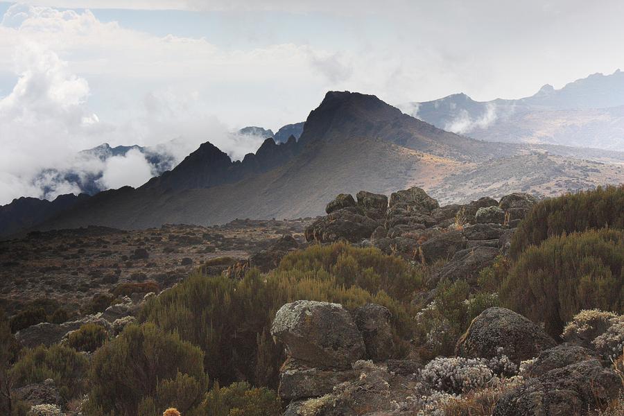
A short steep climb up the famed Barranco Wall leads us to an undulating trail on the south-eastern flank of Kibo, with superb vistas of the southern icefields. The terrain changes to volcanic scree, with pockets of lush vegetation in sheltered hollows, and a powerful sense of mountain wilderness.
video footage from the Barranco Wall 2017. This is a tricky section where you have to hug the wall closely to get around a protruding rock
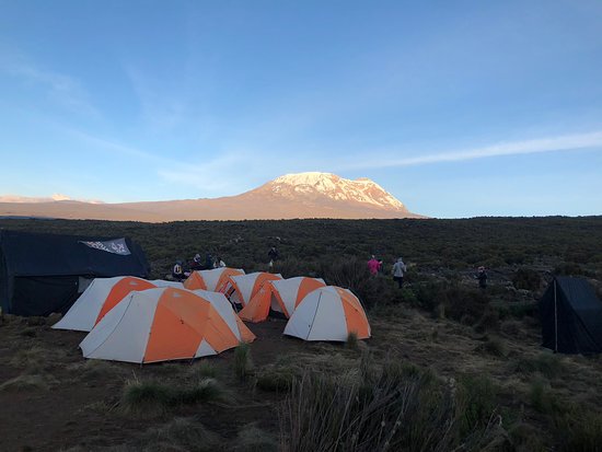
Our next camp is at Karanga (4000m) a short distance away. The valley floor has the last water point on the approach to Barafu and we camp on the higher sides of the valley with views towards the glaciers of the southern icefields. Approx 4-5 hours walking.
We are now sleeping at high altitude with one more camp to go before we make our summit attempt. The landscape now is barren, but beautiful. For me at least, the altitude sickness has calmed down. All I need to do now is breathe and keep moving one step at a time.
Karanga Camp. I don’t actually remember this camp very well. Altitude will do that to you.
August 2 – Day Six
This is a good day to rest – you will be getting up around 10:30 pm for your ascent to the summit
Steep ascent to Barafu campsite (4600m), with optional afternoon ascent to the bottom of S.E. Valley (4800m).
The trail follows a path on compacted scree with wide views ahead including the Barafu Ridge where our camp lies. The trail climbs unrelentingly to reach the Barafu campsite (4600m) for lunch, after which there is a short acclimatization walk to the plateau at the bottom of the southeast valley (4800m). The remainder of the day is spent resting in preparation for the final ascent and includes a very early night.
Approx 3-5 hours walking.
In honour of this day and to walk under the same moon, we will be doing a night walk tonight around the time we would be getting up for the summit attempt. This will be part of the Kilimanjaro Challenge put together by Nathalie and Remi Roy.
Heading from Karanga Camp to High Camp at Barafu. This is a slow and steady hike which takes 3/4 hours to get to high camp. Take your time as you ease your way to high camp.
August 3 – Day Seven
(full moon)
An early start to reach Stella Point in time for sunrise; on to Uhuru Peak (5895m), the highest point in Africa; descend to Millennium Camp (3800m).
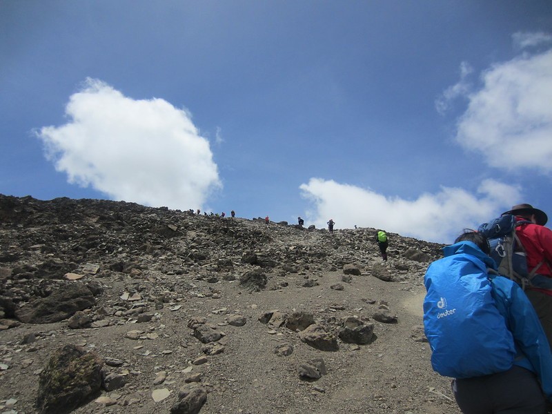
We will start our ascent by torchlight around midnight so that we can be up on the crater rim by sunrise. The steep climb over loose volcanic scree has some well-graded zig-zags and a slow but steady pace will take us to Stella Point (5735m), in about five or six hours.
We will rest there for a short time to enjoy the sunrise over Mawenzi. Those who are still feeling strong can make the two hour round trip from here along the crater rim to Uhuru Peak (5,895m), passing close to the spectacular glaciers and ice cliffs that still occupy most of the summit area.
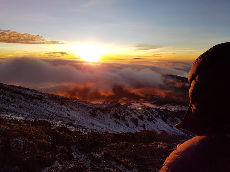
This shot was taken with my phone on a cold morning ascent of Kilimanjaro. I took the picture then forgot about it. High altitude can easily do that to you!
The descent to Barafu is surprisingly fast, and after some refreshments, we continue to descend to reach our final campsite (3800m) at Millenium camp. Most of us will be too tired to notice the beauty of the forest surrounding the crowded campsite. This is an extremely long and hard day with between 11 and 15 hours of walking at high altitude.
Our group shot at Stella Point, probably around 9:30 April 2017. Stella Point (5739 m) is on the crater rim but it is still a two-hour return journey to Uhuru Peak (5895 m)
Once we had all gathered at Stella Point, I actually turned off my tracker. To my oxygen-starved brain, I was done. To people back home, it looked like I had fallen off the edge of the world.
Tracking the night of April 7. There is no track back…
Finally, a great video taken at sunrise going up towards the crater. Look at how slowly these climbers are going! At sunrise, they are at Stella Point. The group makes it to Uhuru – a beautiful series of shots. You can actually see the curvature of the Earth! I really want to make it to Uhuru next time!
August 4 – Day Eight
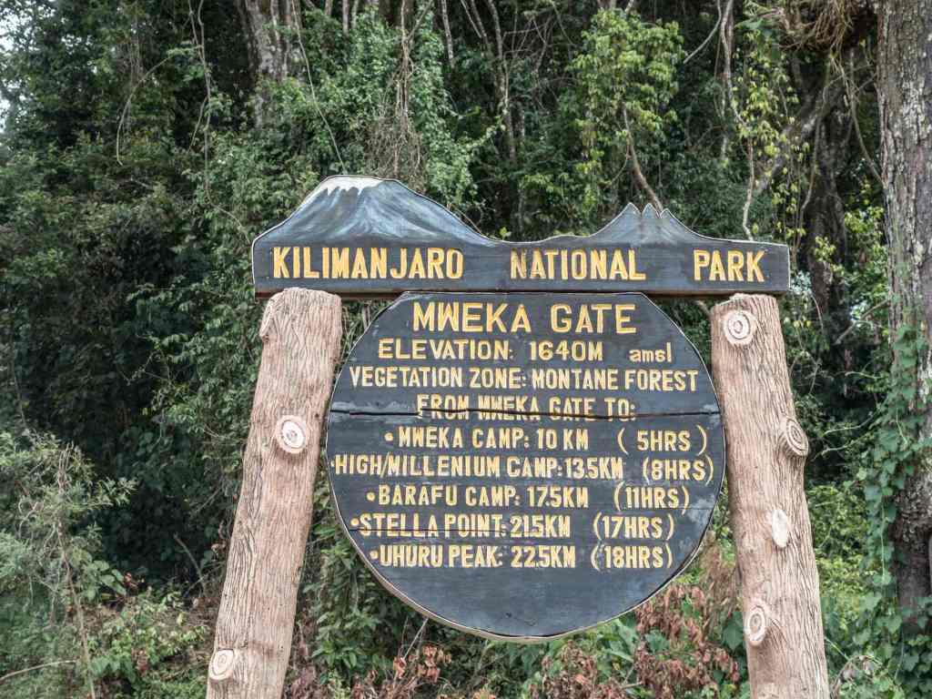
To Mweka Gate; transfer to Arusha.
You have descended 4255m in a day – it is great to be at low altitude again!
This day is a sustained descent on a well-constructed path through lovely tropical forest alive with birdsong and boasting lush undergrowth with considerable botanical interest. Our route winds down to the national park gate at Mweka (1650m); and on through coffee and banana farms to Mweka village. The shower, the beer, and the swimming pool are tantalizingly close! We return by bus to Arusha (a distance of about 100 km). Approx 4-6 hours walking.
The final day coming from Mweka camp 3,100m and exiting the national park at 1,900m. These last two days are tough going up to the summit at 5,895, to 1,900m do not underestimate this challenge.
2 responses to “Kilimanjaro Day-by-Day in the times of COVID”
swailhb
Thanks for doing this, Paul. So, at this point, at 11 am our time in Canada, we would be in Arusha?
Very sad we are not doing this but appreciate the chronicling and one day, I will do it!


Leave a comment